VISIR-2 is a numerical model realised by the CMCC Foundation.
News
We could post news, bug information, patches, and software updates regarding VISIR-2 here or at:
2026
May
20260507 | VISIR-2 as a solution for the EU Mission “Restore our Ocean and Waters”
The ship routing model by CMCC is also part of a booklet with solutions selected for their impact, scalability and replication potential. These solutions create measurable environmental, social, or economic benefits aligned with the mission’s goals.
April
20260425 | 1000 VISIR downloads!
The VISIR-2 (in Python) and VISIR-1 (in Matlab) ship weather routing models by the CMCC Foundation - Centro Euro Mediterraneo sui Cambiamenti Climatici have cumulatively reached one thousand downloads on Zenodo, with three-quarters coming from VISIR-2. The journal paper documenting it received 22 peer-reviewed citations in less than two years, with a field-weighted citation impact of 3.9 according to Scopus.
2025
June
20250628 | VISIR-2 gallery now available
A gallery is now available as part of the official web documentation. Insights generated by the VISIR-2 ship routing model over the past few years can now be browsed in a light and visual format.

May
20250523 | VISIR-2 v6 released
A new release of the VISIR-2 model (v6) has been published today. As with previous versions, it is available for download on Zenodo. This release includes a significant bug fix and adds support for additional shoreline data providers. Details about the bug and its impact are provided here, while a complete list of changes introduced in version 6 can be found here.

February
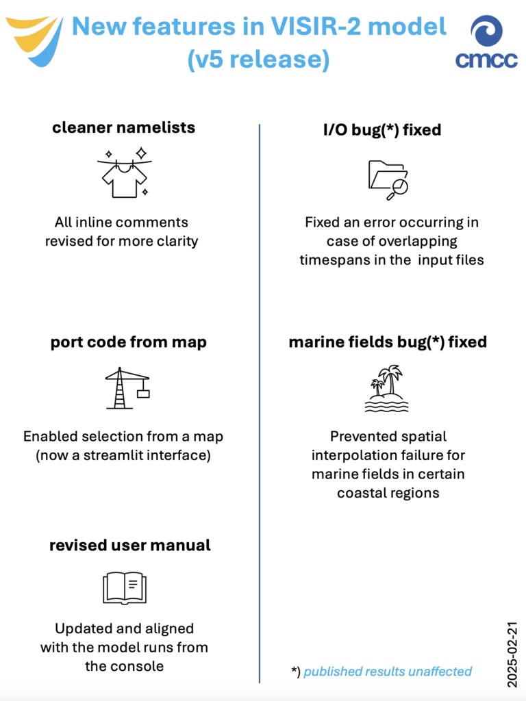
20250221 | VISIR-2 v5 released
The fifth version of the VISIR-2 ship weather routing model has been released today. This latest update, available on Zenodo, introduces new functionalities and bug fixes.
Notable improvements include clearer inline comments in the input namelists, which help configure numerical simulations, and an enhanced graphical user interface that simplifies port code searches. The user manual has also been updated.
Two bugs have been fixed: one related to input fields with overlapping timespans, another concerning marine field pre-processing in certain coastal regions. However, neither of these issues affected previously published results.
VISIR-2 users are encouraged to provide feedback at any time via the web form.
January
20250129 | VISIR-2 video tutorial
A common request from the feedback form of VISIR-2 was for a video tutorial to help with installation and first-run operations. CMCC has addressed that by creating this short video, which we hope you’ll find helpful.
The feedback form remains open for any further feedback!
20250107 | VISIR-2 feedback form
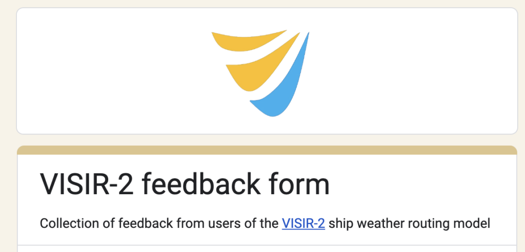
A simple yet structured online form is now available for providing feedback on the VISIR-2 ship weather routing model. The form includes a combination of open- and closed-ended questions to capture users’ impressions of the Python-based software. The collected feedback will help guide the strategy for improving VISIR-2, with updates reflected in future releases. The development team thanks all users for their valuable contributions.
2024
November
20241129 | New release of VISIR-2
As part of CMCC Foundation‘s ongoing commitment to enhancing the open-source VISIR-2 ship routing model, a new update has been released today.
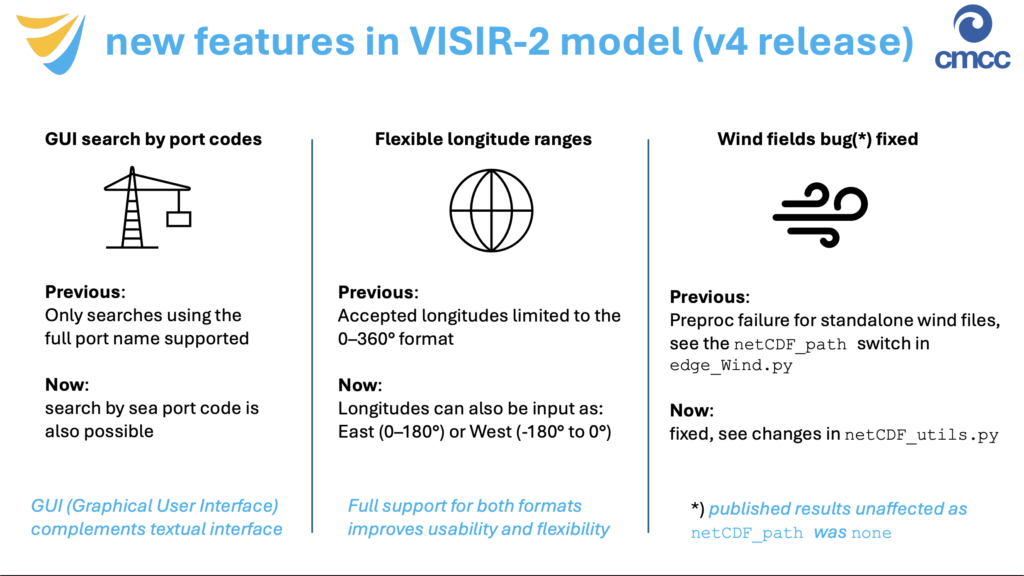
This release introduces new functionalities and resolves a bug, improving the overall user experience. Users can now search for ports of call using their international codes via the dedicated graphical interface. Additionally, for those entering coordinates, the system now supports longitudes in both the 0–360° format and the East (0–180°) or West (-180° to 0°) format for added flexibility. The update also fixes a bug in the preprocessing of standalone wind files, though fortunately, previously published results were unaffected.
The latest version of the VISIR-2 source code is available for download at https://doi.org/10.5281/zenodo.14244993 .
The model in documented in the peer-reviewed journal papers:
– https://doi.org//10.5194/gmd-17-4355-2024
– https://doi.org//10.1088/1742-6596/2867/1/012003
October
20241024 | Two new papers on VISIR-2
The Python-coded ship weather routing model VISIR-2 has been documented in two peer-reviewed papers published this year.
The first, published in Geoscientific Model Development, provides a comprehensive overview of the model’s geometry, kinematics, vessel performance modelling, path optimisation procedures, and visualisation capabilities. The paper also assesses the model’s numerical performance and demonstrates its application by evaluating CO2 savings for a ferry in the western Mediterranean Sea and time savings for a sailing boat in the Aegean Sea.
The secondpaper, published as part of theMTEC-ICMASS 2024 conference proceedings, presents a case study involving a ferry in the Skagerrak, the sea between Norway and Denmark. This work offers a concise introduction to VISIR-2 and evaluates the potential CO2 savings achievable in the presence of waves and currents, while also discussing current model limitations and future improvements.
The VISIR-2 description is further complemented by introductory presentations for both the model and its source code, which are available on the Zenodo community page: https://zenodo.org/communities/visir2/.
March
20240312 | Important notice to all VISIR-2 users
During the peer-review of the latest manuscript regarding the VISIR model (https://doi.org/10.5194/egusphere-2023-2060-AC2) it became apparent that a cartographic projection was missing.. This oversight impacted ship course calculations.
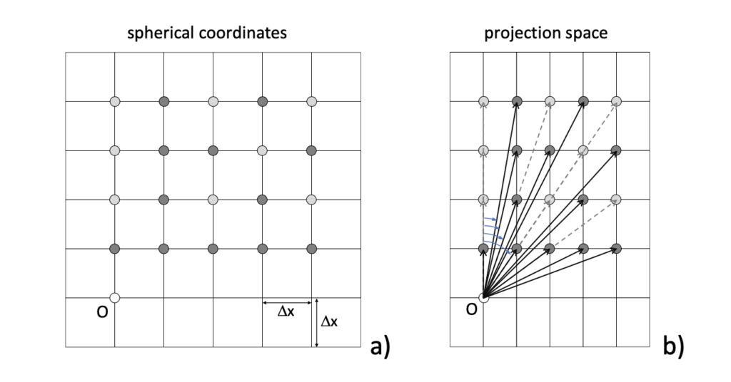
The bug has been addressed by releasing a new version of VISIR-2 (Python) and applying a patch to VISIR-1 (Matlab). It is strongly recommended to download the updates as provided below and re-run previous calculations for accuracy.
The VISIR development team apologises for any inconvenience caused. Here are the fixes to address this bug in both models:
VISIR-2: https://zenodo.org/records/10682896
VISIR-1: https://zenodo.org/records/10803793
Please feel free to reach out if you have any feedback or need clarification.
2023
November
20231116 | VISIR-2: both preprint and source code published
Today, a manuscript detailing the comprehensive documentation of the Python-coded VISIR-2 ship routing model has been released.
VISIR-2, an open-source model, is designed to calculate least-CO2 routes in the presence of waves and currents. Additionally, it determines least-time routes for sailboats, considering both currents and leeway. This modular, Python-coded system has been validated and is notably ten times faster than its predecessor, VISIR-1, in computing optimal paths.
The source code for VISIR-2, accompanied by multiple input datasets, has been made publicly available on Zenodo.
The manuscript now embarks on its academic journey, inviting official reviewers and the wider scientific community to contribute their critical assessments and feedback. This is made possible through the innovative open-review process facilitated by Copernicus Publications.
A video showcasing one-year least-CO2 optimal routes computed using VISIR-2 is accessible here. Additionally, a corresponding video featuring optimal routes for a sailboat can be found here.
January
20230123 | VISIR-2 routes on the EMOD-PACE map viewer
The EMOD-PACE (EMODnet PArtnership for China and Europe) project now displays VISIR-2 routes on its map viewer.

Least-CO2 routes of a 800 TEU feeder (a small container ship) calling at Singapore and other harbours along the maritime silk road can be explored via the viewer.
The routes were computed for several months and departures dates in 2020 and were documented in terms of both their CO2 and CII (Carbon Intensity Indicator) relative savings with respect to the least-distance route.
The vessel seakeeping is based on semi-empirical parametrisations selected in the frame of the PhD-thesis by Amal Salhi to be defended during the upcoming PhD-graduation session at the University of Bologna.
The EMOD-PACE project, which established a long term ocean data collaboration between the National Marine Data and Information Service of China (NMDIS) and the European Marine Observation Data Network (EMODnet) was funded by the EU Partnership Instrument
(EuropeAid/139904/DH/SER/CN ‘Strengthening international ocean data through the EU’s ocean diplomacy with China’).
Project video: https://www.youtube.com/watch?v=3ONwjZTI4uA